

3.5 miles, 800′ gain, easy intermediate
The Potluck
After the hike, we’ll enjoy a potluck at another location a few miles away. The location will be announced at the trailhead.
Please bring some food and drink to share. If your item requires it, bring plates and utensils to share. Please leave your potluck items in your car.
snack share
Nearly the entire trail is an incline. Fit beginners can complete this hike, but it will certainly get their blood pumping.
There are no super steep sections, but much of the trail is rugged, much like a stair climb. This is not a conditioning hike, it’s a social hike. We’ll be stopping at various points to let people catch up and to make sure they make any turns.
The hike covers a portion of an old stagecoach road that linked LA with San Francisco in the 1860s. You can see holes that, according to others, were drilled into the rock for chains to help the stagecoaches up the steeper sections, during which passengers had to get out of the vehicle.
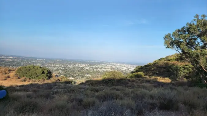
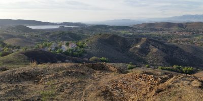
We will begin near the intersection of Andora and Valley Circle. We’ll proceed up a rocky trail past a plaque erected in 1939 to commemorate the old stagecoach route, then we’ll proceed to the top of the pass for a great view overlooking the valley.
There are a variety of ways of getting to the same place and returning. Please follow the host to take the chosen route. The return route may be slightly different than the way up through a parallel path. The host may mark the path on the way up using baking soda.
The Hike
Distance: 3.5 miles
Gain: 800′
Distribution: Most of the incline is in the first half.
Difficulty: Easy Intermediate.
Shape: Out and Back.
Pace: approx. 2.0 mph.
Trail Type: Fire road, double track, single track.
Trail Variations: Some parts of the trail are rugged.
Duration: 3.5 hours
Dogs: Yes.
Restrooms: Yes.
Drinking Fountains: No.
Parking: Park on the street.
What to bring:
1 liter of water for every 3 miles.
Hiking shoes/boots. Not required, but recommended.
Flashlight or headlamp.
Sunscreen and/or hat as needed.
Hosting
Route: The host knows the route.
Navigation: Host memory, enhanced by GPS navigation as needed.
Hike type: Social.
We won’t be hiking at a fast pace because this is a social hike, not a conditioning hike. There is nothing wrong with stopping, even if it means every 50 steps.
Each hiker is responsible for knowing their capability, only attending events where they are able to sustain the described pace, for keeping up with the group sufficiently enough to make the turns and not get left behind, and for making sure the host is notified if they are going to split from the group.
Group separation:
Hikers moving significantly ahead and not waiting at designated stopping points, are on their own regarding route and navigation.
Directions
Stage Coach Trail, Andora trailhead
9861 Andora Ave.
Chatsworth, CA 91311
34.249626, -118.619625
From CA-118
Topanga Canyon (CA-27) south, 1.4 mi
Right (west) on Devonshire St for .4 mi
Left (southwest) on Valley Circle for .6 mi
Right (west) on Lassen for 43 ft.
Left (southwest) on Andora for 157 ft.
FAQ
Hiking Plus Page Links
Disclaimer / Release of Liability


")
")


