

***RSVPs will open APRIL 1, 2024. Add yourself to the waitlist and I will manually add at that time.***
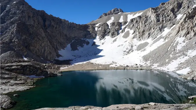
Meysan Lake Trail starting from Whitney Portal
https://www.fs.usda.gov/recarea/inyo/recreation/hiking/recarea/?recid=20804&actid=50
WARNING:
This is a CHALLENGING and STRENUOUS trail that is rocky and extremely steep. Ultralight backpacking strongly recommended. Please be trained, in shape, and acclimated to this high elevation before attending. Mosquitoes will likely be bad, and it will be pretty exposed. In fact, there is no tree cover at all at the campsite up at Meysan Lake.
Trail Stats:
- Mileage: 10-11 miles round trip
- Starting elevation: 8,000 feet
- Ending elevation: 11,600 feet
- Elevation gain: 3,600+ (there is a little bit of loss and gain at the end)
- Water source: Meysan Lake and potential for various streams crossing trail.
- Bear Canisters: not required, but recommended (https://www.fs.usda.gov/Internet/FSE_DOCUMENTS/fseprd937100.pdf)
Itinerary:
- Friday, June 28: camp at Whitney Portal campground or if you can’t get a site, stay in Lone Pine or disperse camp in Alabama Hills.
- Saturday, June 29: meet at Whitney Portal Store at 8am, try to hit trail by 9am. Hike 5 to 5.5 miles over about 4,000 feet of elevation gain to Meysan Lake. Set up camp and enjoy the views of Mt. Mallory and Mt. Irvine While you rest or explore around the lake.
- Sunday, June 30: pack up and hike down to the portal. Grab food or souvenirs at the Store if open. If not, go get food down in Lone Pine.
Be sure to bring:
– Sun protection (clothing and sunscreen. If you have one of those reflective umbrellas i might recommend that too).
– Microspikes: there may still be snow or ice on the trail (we can check on this when we get closer to the trip whether or not we will need these).
– Extra stakes and rope for your tent. It will be mostly rocks at the campsite so it may be difficult to secure it. NO HAMMOCKS.
– InReach or some other way finding device. Apparently the top of the trail gets confusing and it may be easy to get off track. Download trail ahead of time before the trip to track however you like to track.
– A wag bag (rocky granite terrain may not allow for typical Leave No Trace waste burial).
Links to learn more about the trail:
Inyo National Forest Fact Sheet: https://www.fs.usda.gov/Internet/FSE_DOCUMENTS/fseprd530479.pdf
AllTrails:
[https://www.alltrails.com/trail/us/california/meysan-trail?sh=fzrxlq ](Meysan Trail on AllTrails https://www.alltrails.com/trail/us/california/meysan-trail?sh=fzrxlq)
DISCLAIMER: Hike at your own risk. Be responsible for yourself and your safety. Make good decisions. With any trip, things can change, reservations can get lost, the unexpected can happen. A go-with-the-flow attitude is always a good thing, and most importantly, let’s all have fun! This is a moderate to intermediate hike. Make sure you are in good enough physical shape for the distance, elevation changes, and terrain. The hike leaders in this group aren’t professional hike leaders. By signing up for these events, you agree not to hold the Meetup organizers responsible for whatever happens to you on these events. The hiking group does not certify the expertise of the organizers, the event or assistant organizers (hike leaders) and…We are NOT responsible for any possible losses or injuries.


")


